
LIDAR RANGE
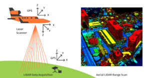
LIDAR, lidar range which stands for Light Detection and Ranging, is a remote sensing technology . From an airplane or helicopter, LiDAR systems send light to the ground.This pulse hits the ground and returns to the sensor. Then, it measures how long it takes for the light to return to the sensor.
Typically, linear LiDAR has a swath width of 3,300 ft. But new technologies like Geiger LiDAR can scan widths of 16,000 ft.
USE OF LIDAR
LIDAR use in the real life
- Air crafts
- Daily life
- Auto mobile
- Mobile phone
- Construction company
AIR CRAFTS
LIDAR, which stands for Light Detection and Ranging, is a remote sensing technology employed in aircraft for various purposes. It involves the emission of laser pulses towards the ground or objects, with the sensor measuring the time it takes for the laser beams to bounce back.
Terrain Mapping: LIDAR helps create high-resolution and precise 3D maps of the terrain below, which is crucial for navigation, obstacle detection, and terrain following in both manned and unmanned aircraft.
Topographic Surveys: Aircraft equipped with LIDAR sensors are used for environmental monitoring, land surveying, and cartography, providing detailed elevation and surface information.
DAILY LIFE
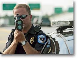
LIDAR (Light Detection and Ranging) technology is commonly employed in traffic police speed detection equipment to measure the speed of vehicles on the road. In this context, LIDAR serves as a highly accurate and efficient method for enforcing speed limits and ensuring road safety.
LIDAR speed detection equipment used by traffic police utilizes laser-based technology to precisely determine the speed of vehicles on roadways. It operates by emitting short pulses of laser light towards a target vehicle and then measuring the time it takes for the light to bounce back after hitting the vehicle. By analyzing the change in distance over time, LIDAR equipment can calculate a vehicle’s speed with exceptional accuracy. This technology enables law enforcement agencies to effectively enforce speed limits, identify speeding violations, and contribute to road safety by promoting responsible driving behavior.
AUTO MOBILE
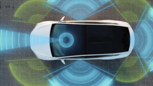
LIDAR (Light Detection and Ranging) sensors have significant applications in the automobile industry, where they are used for advanced driver assistance systems (ADAS) and autonomous vehicles.
LIDAR sensors in the automobile industry are cutting-edge devices that employ laser light pulses to create detailed 3D maps of the vehicle’s surroundings. These sensors play a pivotal role in enhancing automotive safety and enabling autonomous driving. LIDAR sensors enable vehicles to accurately perceive their environment, detect obstacles, pedestrians, and other vehicles, and make real-time decisions to navigate and operate safely. They are integral components of advanced driver assistance systems (ADAS) and are crucial for achieving higher levels of automation in the automotive sector, contributing to improved road safety and the development of self-driving cars.
MOBILE PHONES
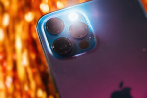
LIDAR (Light Detection and Ranging) sensors in mobile phones are advanced hardware components designed to enhance the device’s spatial perception and augmented reality (AR) capabilities.
LIDAR sensors in mobile phones are specialized components that emit laser pulses and measure the time it takes for these pulses to bounce back after hitting objects in the phone’s surroundings. This technology allows mobile phones to create precise depth maps and 3D models of the environment, enabling features such as improved augmented reality experiences, more accurate portrait mode photography, and enhanced object recognition. LIDAR sensors in mobile phones empower developers to create innovative applications and games that interact with the real world in three dimensions, ultimately offering users a richer and more immersive mobile experience.LIDAR (Light Detection and Ranging) sensors in construction tools are specialized instruments that utilize laser technology to accurately measure distances and create detailed 3D representations of construction sites and structures. Here’s a definition:
“LIDAR sensors in construction tools are advanced devices that emit laser pulses and capture the reflected light to generate highly accurate 3D maps and measurements of construction environments. These sensors are integral in construction applications for tasks such as site mapping, building layout, as-built documentation, and quality control. By providing precise data on distances, elevations, and spatial information, LIDAR sensors significantly enhance efficiency, accuracy, and safety in construction projects, enabling better decision-making and project management.”
CONSTRUCTION COMPANY
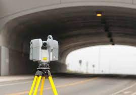
LIDAR (Light Detection and Ranging) sensors in construction tools are specialized instruments that utilize laser technology to accurately measure distances and create detailed 3D representations of construction sites and structures.
LIDAR sensors in construction tools are advanced devices that emit laser pulses and capture the reflected light to generate highly accurate 3D maps and measurements of construction environments. These sensors are integral in construction applications for tasks suchS as site mapping, building layout, as-built documentation, and quality control. By providing precise data on distances, elevations, and spatial information, LIDAR sensors significantly enhance efficiency, accuracy, and safety in construction projects, enabling better decision-making and project management.
FAQ’s
What is the maximum range of LiDAR?
The detection distance is up to 2000m with ±2cm accuracy. Widely used in HD maps, smart cities, city 3D modeling, land survey, fire emergency, power inspection, track inspection, mine inspection, tunnel inspection, forest inspection, bridge anti-collision and other fields.
Is LiDAR 100% accurate?
LiDAR sensors are able to achieve range accuracy of 0.5 to 10mm relative to the sensor and a mapping accuracy of up to 1cm horizontal (x, y) and 2cm vertical (z).
How far can iPhone LiDAR see?
Apple’s latest products, the iPhone 12 Pro and Pro Max, iPhone 13 Pro and Pro Max, and iPad Pro now feature a built-in lidar scanner that can create 3D representations of close-range objects (up to 5 m away).
RELATED TOPICS
PNP SENSOR:https://solutionsensor.com/pnp-sensor/
PNP AND NPN SENSOR WIRING:https://solutionsensor.com/pnp-and-npn-sensor-wiring/
LIQID LEVEL CONTROL SYSTEM:https://solutionsensor.com/liquid-level-control-system/